Ouest Magpie 2019
General Information
Number of participants: 3
Number of days: 12
Water Level: Low
Trip Dates: Two weeks in the middle of September
Total KM: 260
Total Elevation drop: almost 2000ft
Maps used: 1:250000 (22P, 22I) 1:50000 (22P/13, 22P/14, 22P/11, 22P/6 22P/3, 22P/2, 22I/15, 22I/8, 22I/9, 22I/10)
Gauge: https://www.cehq.gouv.qc.ca/suivihydro/graphique.asp?NoStation=073503
General weather: average for September. We did not get snow at the put in, or in the first few days. But we have heard of people getting it. We did have ice in our bottles one morning.
Pace of trip: relaxed
Campsites: The flat water approach has many beaches and lots of cozy pockets in the woods, great camping. The West Magpie has lots of great camping as well. Lac Magpie is absolutely stunning and has plenty of beaches. The Magpie has plenty of established campsites, it will make your life way easier finding them if you bring along the Cartes Plein Air annotated map of the Magpie.
Whitewater overview: The West Magpie is steep, continuous mountain river, a lot can go wrong out there. Scout often! The West Magpie has also been known to flash flood with sustained large amounts of rain. The Magpie has a more traditional big water feel.
Sept Iles: Great Town to Start an expedition in. It has everything that you would need, Walmart, Tims Ext. Hot Tip, Gino's has really good pizza! To sleep; there is a wide variety of hotels and motels, a thriving Tinder scene, the Walmart parking lot, and a quiet little park near the train station.
The Train: Take it!!! it is so beautiful out there, never once was our group board. The train ride in is absolutely stunning. The “flat” water is not really that bad as the river moves at around 2km/hr and has occasional rapids. It also gives you time to figure out your systems for your group; morning rituals, packing your boat and how your boat feels fully loaded. Lastly: YOU HAVE TO EARN YOUR TURNS!!! nuff said. The Train ticket is fixed, but your kayak can cost really what ever the person at the desk decides to charge you. Do not call it a kayak, do not call it a canoe. Say its a wave ski and its over 4ft long. Hopefully this will cost less then a canoe (140$)
Day 1
HoW: 230-630
Distance: 18km
Weather: rain,sun,tailwinds, cold
Campsite: 214 443 22 P/13 end of the last rapid, Lovely taiga, and soft caribou moss.
Tech:
Day 2
HoW: 1030-4
Distance: 25km
Weather: sunny, tailwinds
Campsite:346 285 22 P/11 tucked in the woods back from a beach, also on caribou moss
Tech:
Shallow meandering, but moving river (around 2km/hr). All narrows have swifts.
Day 3
HoW: 1030-4
Distance: 29km
Weather: cloudy, usual northern weather
Campsite: 417 154 22 P/11 Island campsite, this is an established site.
Tech:
n/a
Synopsis:
A wee bit flat, but the the river is still moving. Also look out for the really, really shallow areas.
Day 4
HoW: 1020-4
Distance: 23km
Weather: really cold, rainy, tailwind
Campsite: 457 943 22 P/11 river left at a small beach in the pool after the Entrance Falls gorge.
Tech:
Day 5
HoW: 1020-350
Distance: 19km
Weather: sun, warm, a bit of cloud
Campsite: 543 852 Large flat rock RL after the river calms down. It is marked by two crossed paddles high in a tree. There is also a broken canoe in the bushes up the hill.
Elevation drop: 250ft
Tech:
Wow The West Magpie Speaks! The views are stunning, if you take the time to look around from the white water. We have the utmost respect for the canoeists and rafters who have walked down this river.
Day 6
HoW: 11-4
Distance: 28km
Weather: warm, sunny, bit of cloud
Campsite: 607 592
Tech:
Day 7
HoW: 9:30-7
Distance: 22km
Weather: cloudy, cold, sun, rain, literally everything
Campsite: 815 547 22 P/2
Elevation drop: 500ft
Tech:
A lot can go wrong today, take your time and scout.
Day 8
HoW: 1-4
Distance: 12km
Weather: Tailwinds, sun and cloud got cold at the end
Campsite: 850 433 22 I/15
Tech:
Day 9
HoW: 1030-445
Distance: 23km
Weather: hot, calm
Campsite: 866 208 I/10
Tech:
N/A
Day 10
HoW: 1010- 345
Distance: 28km
Weather: cloudy, chilly, head wind
Campsite: 994 205. Should have pushed a little further, there would have been something nicer
Tech:
Day 11
HoW: 10-345
Distance: 26km
Weather: cloudy, slight head wind, warm
Campsite: Bellow the massive Magpie Gorge 986 812 RL. There is also a camp site near the start of the portage trail.
Tech:
Day 12
HoW: 10-12
Distance: 6km
Weather: grey, rainy
Campsite: N/A
Tech:
Number of participants: 3
Number of days: 12
Water Level: Low
Trip Dates: Two weeks in the middle of September
Total KM: 260
Total Elevation drop: almost 2000ft
Maps used: 1:250000 (22P, 22I) 1:50000 (22P/13, 22P/14, 22P/11, 22P/6 22P/3, 22P/2, 22I/15, 22I/8, 22I/9, 22I/10)
Gauge: https://www.cehq.gouv.qc.ca/suivihydro/graphique.asp?NoStation=073503
General weather: average for September. We did not get snow at the put in, or in the first few days. But we have heard of people getting it. We did have ice in our bottles one morning.
Pace of trip: relaxed
Campsites: The flat water approach has many beaches and lots of cozy pockets in the woods, great camping. The West Magpie has lots of great camping as well. Lac Magpie is absolutely stunning and has plenty of beaches. The Magpie has plenty of established campsites, it will make your life way easier finding them if you bring along the Cartes Plein Air annotated map of the Magpie.
Whitewater overview: The West Magpie is steep, continuous mountain river, a lot can go wrong out there. Scout often! The West Magpie has also been known to flash flood with sustained large amounts of rain. The Magpie has a more traditional big water feel.
Sept Iles: Great Town to Start an expedition in. It has everything that you would need, Walmart, Tims Ext. Hot Tip, Gino's has really good pizza! To sleep; there is a wide variety of hotels and motels, a thriving Tinder scene, the Walmart parking lot, and a quiet little park near the train station.
The Train: Take it!!! it is so beautiful out there, never once was our group board. The train ride in is absolutely stunning. The “flat” water is not really that bad as the river moves at around 2km/hr and has occasional rapids. It also gives you time to figure out your systems for your group; morning rituals, packing your boat and how your boat feels fully loaded. Lastly: YOU HAVE TO EARN YOUR TURNS!!! nuff said. The Train ticket is fixed, but your kayak can cost really what ever the person at the desk decides to charge you. Do not call it a kayak, do not call it a canoe. Say its a wave ski and its over 4ft long. Hopefully this will cost less then a canoe (140$)
Day 1
HoW: 230-630
Distance: 18km
Weather: rain,sun,tailwinds, cold
Campsite: 214 443 22 P/13 end of the last rapid, Lovely taiga, and soft caribou moss.
Tech:
- R2 554 108 22 P/13
- R1s till 530 115
- R1 447 183
- R1 205 437
- R2 209 439
Day 2
HoW: 1030-4
Distance: 25km
Weather: sunny, tailwinds
Campsite:346 285 22 P/11 tucked in the woods back from a beach, also on caribou moss
Tech:
- R2 256 375 ran RL of island
- R3 262 374
- Paddled over bend in river at 293 353 22 P/11
Shallow meandering, but moving river (around 2km/hr). All narrows have swifts.
Day 3
HoW: 1030-4
Distance: 29km
Weather: cloudy, usual northern weather
Campsite: 417 154 22 P/11 Island campsite, this is an established site.
Tech:
n/a
Synopsis:
A wee bit flat, but the the river is still moving. Also look out for the really, really shallow areas.
Day 4
HoW: 1020-4
Distance: 23km
Weather: really cold, rainy, tailwind
Campsite: 457 943 22 P/11 river left at a small beach in the pool after the Entrance Falls gorge.
Tech:
- R2 488 055
- R2 487 043
- R2 476 027
- R3+ 456 953
- Entrance Falls R5 456 947 portage/scout RL 200m. Lower boats or seal launch at the very end.
- R3/4 456 945 ran RR
Day 5
HoW: 1020-350
Distance: 19km
Weather: sun, warm, a bit of cloud
Campsite: 543 852 Large flat rock RL after the river calms down. It is marked by two crossed paddles high in a tree. There is also a broken canoe in the bushes up the hill.
Elevation drop: 250ft
Tech:
- R2 458 959
- R1/swifts 465 929
- Continuous R2/3 474 919
- R3 (Pride rock) 479 880
- R3 488 876
- R4 497 875
- R2 503 875
- R5 511 877 Portage/scout RL. Feeds into...
- Continuous R3/4 with the occasional R5, we scouted 4 times. Ends at 536 863
- R2/3 pool drop till the campsite
Wow The West Magpie Speaks! The views are stunning, if you take the time to look around from the white water. We have the utmost respect for the canoeists and rafters who have walked down this river.
Day 6
HoW: 11-4
Distance: 28km
Weather: warm, sunny, bit of cloud
Campsite: 607 592
Tech:
- Continuous R2/3 after campsite (543 852)
- R2/3 551 828
- R3 556 812
- R3 556 802
- R2/3 556762
- R3/4 549 753
- Swifts/R1/2 549 758- 554 706
- R3 556 655
Day 7
HoW: 9:30-7
Distance: 22km
Weather: cloudy, cold, sun, rain, literally everything
Campsite: 815 547 22 P/2
Elevation drop: 500ft
Tech:
- 2/3 614 587
- Continuous R4/5 from 614 575- 619 561 scouted 4 times
- R2/3 624 555
- R4 632 547
- Continuous R3/4 from last rapid till...
- R4/5 651 543
- R4 665 540
- Continuous R4/5 from above till 681 533, scouted twice
- Continuos R4 from 684 535 till...
- R5 697 533 Portage trail RL, established camp RL at the bottom, great veiw!
- R4 701 534
- R2/3 702 534- 708 543
- Possible camp at 755 545
- R4 760 549
- R3/4 775 549
- Unrunable Falls 785 546 Portage RL 600m. There is a small rapid leading up to the falls, get out early, to scout/ portage the falls. The Portage is in the last available eddy. You do not need to catch this eddy, you can get out early in the big eddy just up stream. At our levels (low) it may be possible to run the end of the gorge . This would require extensive scouting, bush walking, and a 20ft seal launch, Its at the end of a long day, make a good call, portage. The trail is well used although very steep at the start, and extra steep at the end.
A lot can go wrong today, take your time and scout.
Day 8
HoW: 1-4
Distance: 12km
Weather: Tailwinds, sun and cloud got cold at the end
Campsite: 850 433 22 I/15
Tech:
- Sailed after sand bar at 825 532
Day 9
HoW: 1030-445
Distance: 23km
Weather: hot, calm
Campsite: 866 208 I/10
Tech:
N/A
Day 10
HoW: 1010- 345
Distance: 28km
Weather: cloudy, chilly, head wind
Campsite: 994 205. Should have pushed a little further, there would have been something nicer
Tech:
- R3 890 154 22 I/15
- Continuous R1/2 from bellow R3 till...
- R4 923 152
- Continuous R1/2
- R5 953 113 scouted MASSIVE hole RR. Run/ portage RL channel R3/4
- Continuous R1/2
- R3 965 085
- R5 968 086 Scouted RL channel R4, portage RL
Day 11
HoW: 10-345
Distance: 26km
Weather: cloudy, slight head wind, warm
Campsite: Bellow the massive Magpie Gorge 986 812 RL. There is also a camp site near the start of the portage trail.
Tech:
- R3 995 000 Big finish
- All marked rapids are R2/3 till...
- R3 968 915
- R5 975 914 scout/portage RR
- R4 975 906
- R3 975 900
- R4/5 975 883
- R4 976 873
- Magpie Gorge portage 900m 985 814 portage is RR at the bottom of the bay. Hot tip. You can drag over the grass and mud and take out after the next pond to cut out 200m of the portage. Portage is a good trail all the way, and down hill.
Day 12
HoW: 10-12
Distance: 6km
Weather: grey, rainy
Campsite: N/A
Tech:
- Magpie Falls portage 300m RL.
- R2/3 Used to be another chute, but the dam filled it up :(
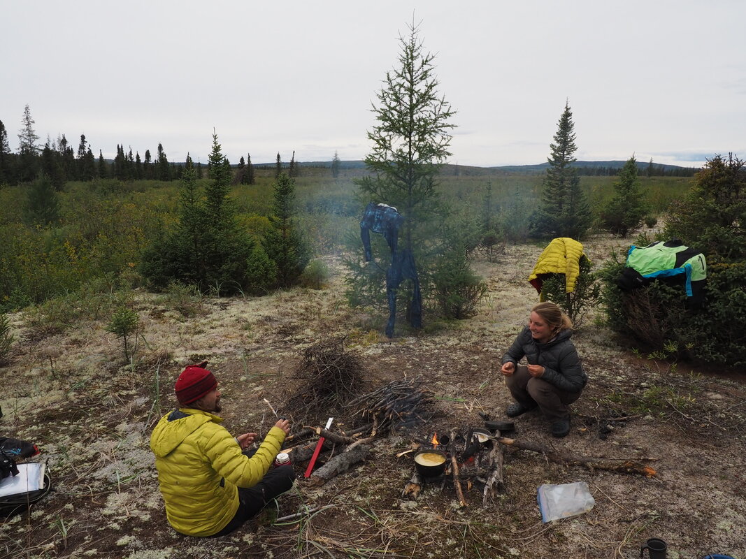
A scenic swamp in the Upper West
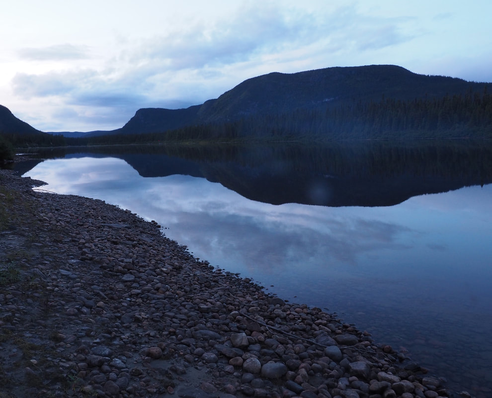
A calm evening before day two of white water
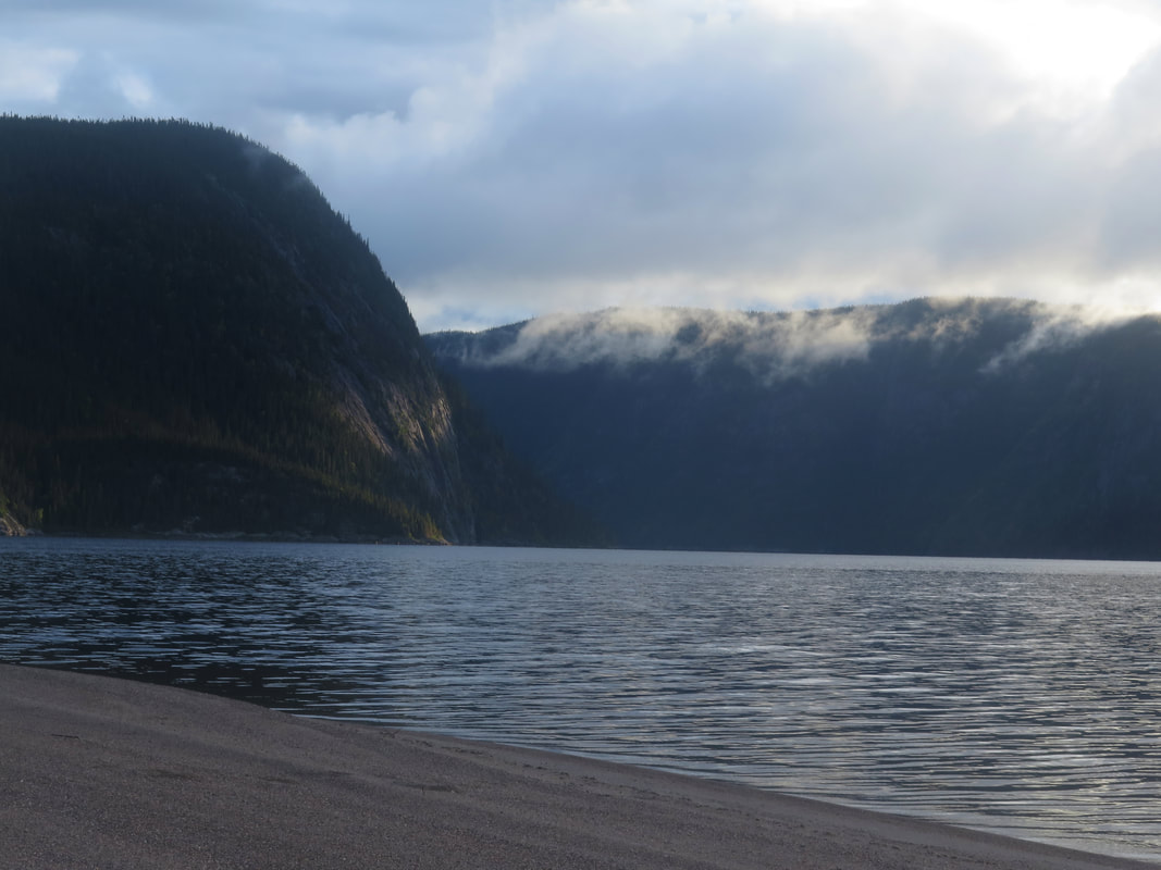
Lac Magpie scenery. Photo by Addie
|
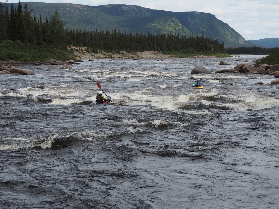
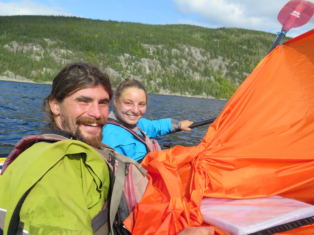
Between the two days of white water. Photo curtesy of Nick
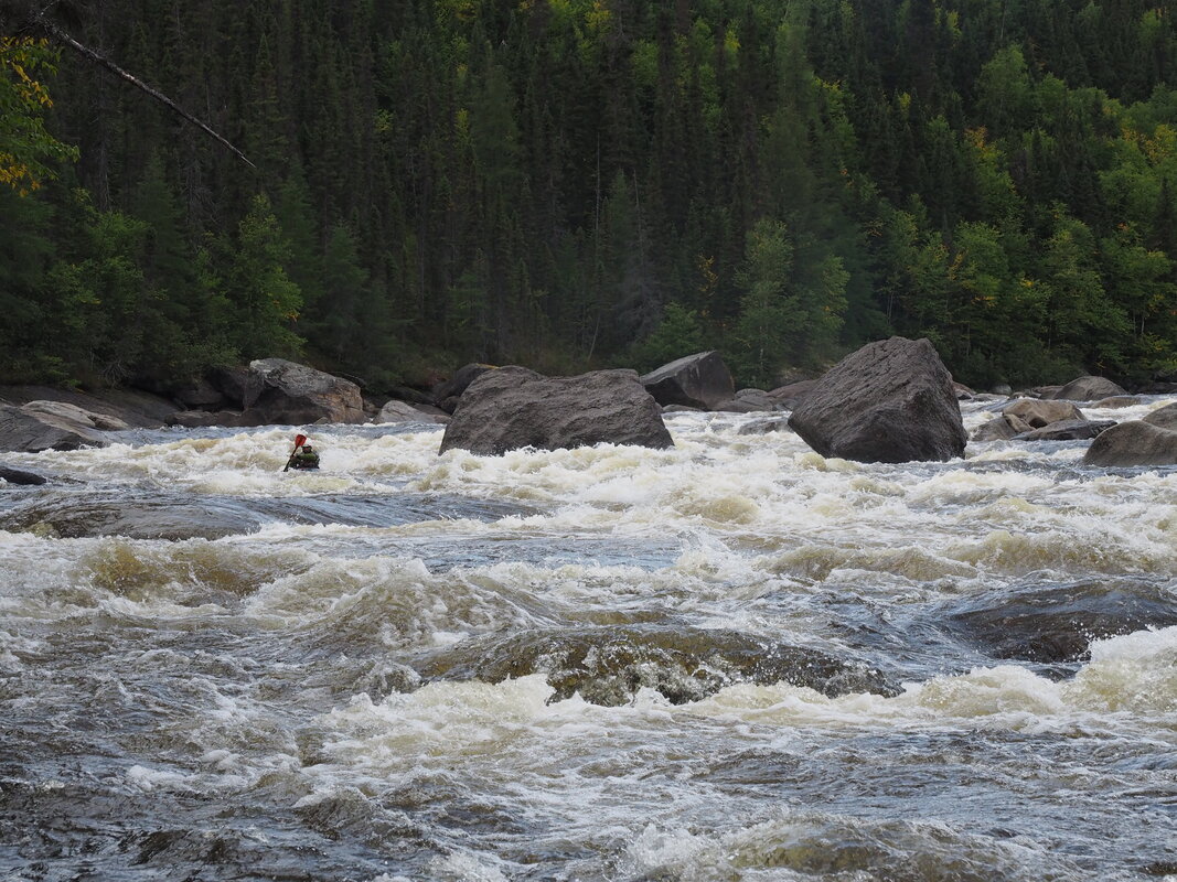
Deep in the canyon on the second day of white water on the West
Sailing down the lake. Photo by Nick on Addie's camera
|
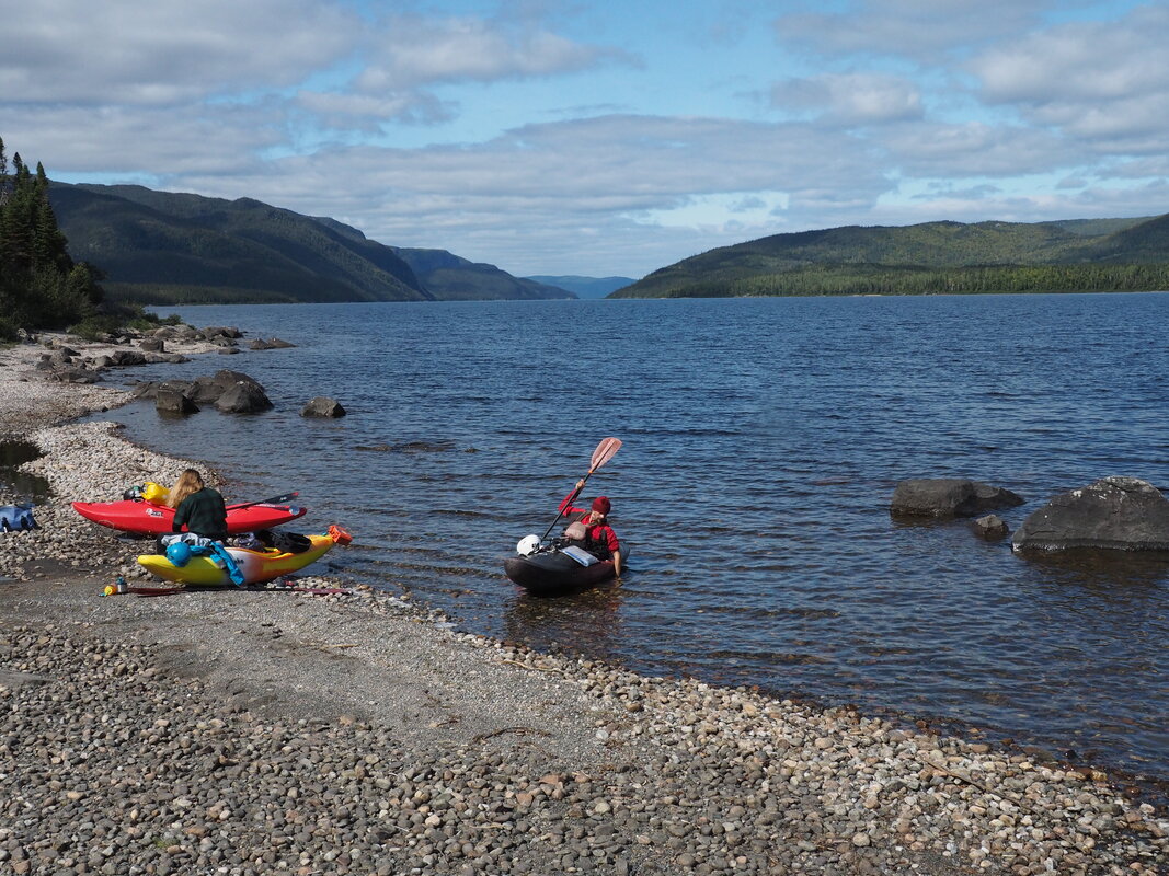
Rest stop on the lake Photo by Nick
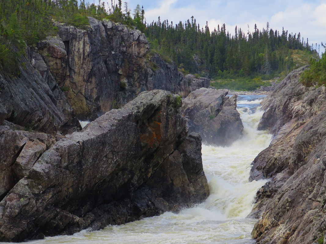
The Magpie gorge. Photo by Addie
|
The end. Photo by Nick
|
