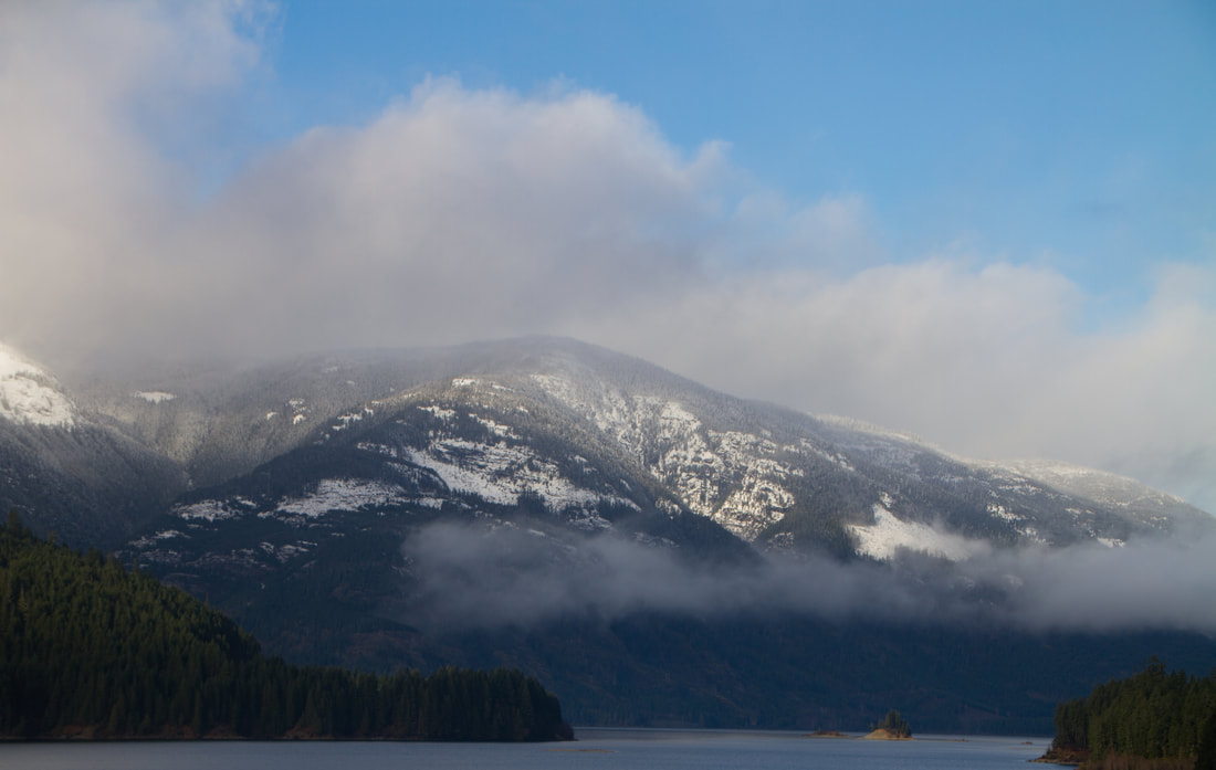
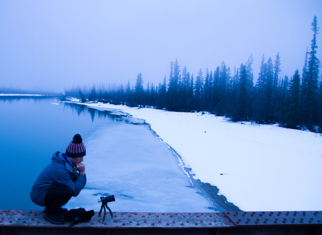
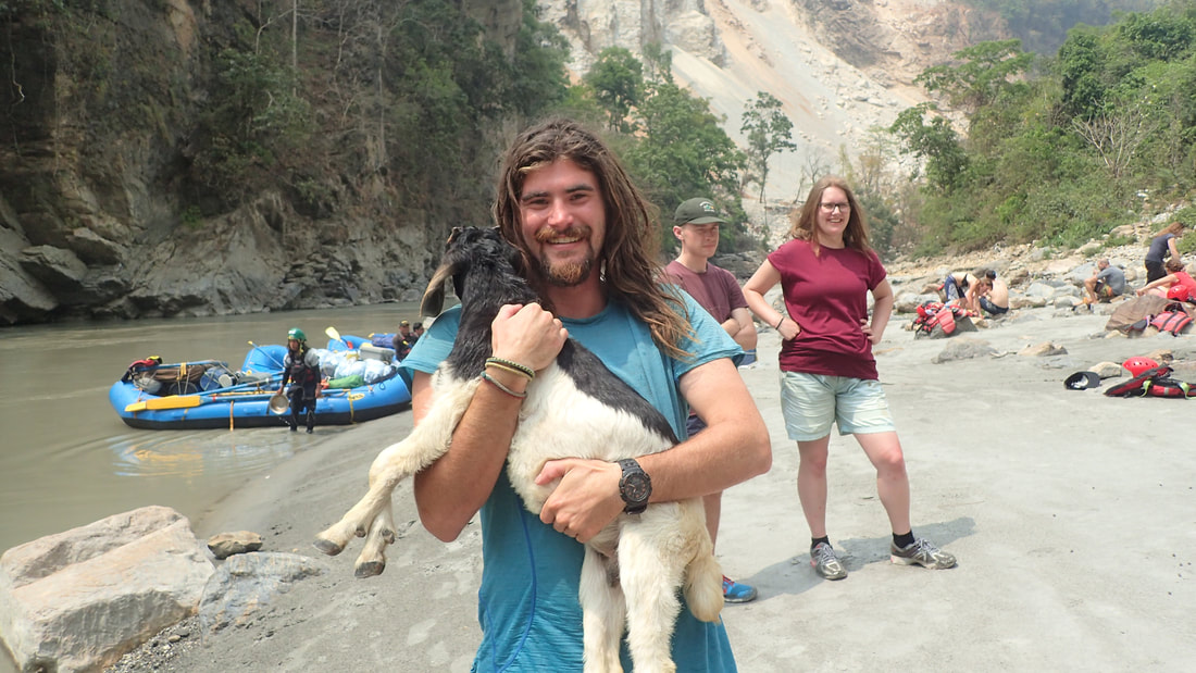
General thoughts and musings while poaching MC'D WIFIAs my time in BC wraps its self up, (I have now left the island and am now in Kamloops BC) I take the opportunity to reflect on my time on Vancouver Island. The buying of the new car obviously was very stressful. However, it allowed me to glimpse first hand the very real problem of homelessness on Vancouver Island, specifically in the Comox valley. The relief when I finalized the purchase of a new car (on December 23rd) was insurmountable. I finally had the freedom to leave the Valley, without the fear that my transmission would die and leave me stranded in the middle of nowhere. I immediately headed back to Gold River, a small forestry town in the central island. The Gold River used to be one of the worlds best Steelhead rivers but, as with many of the rivers on the Island it was decimated during the 20th century. 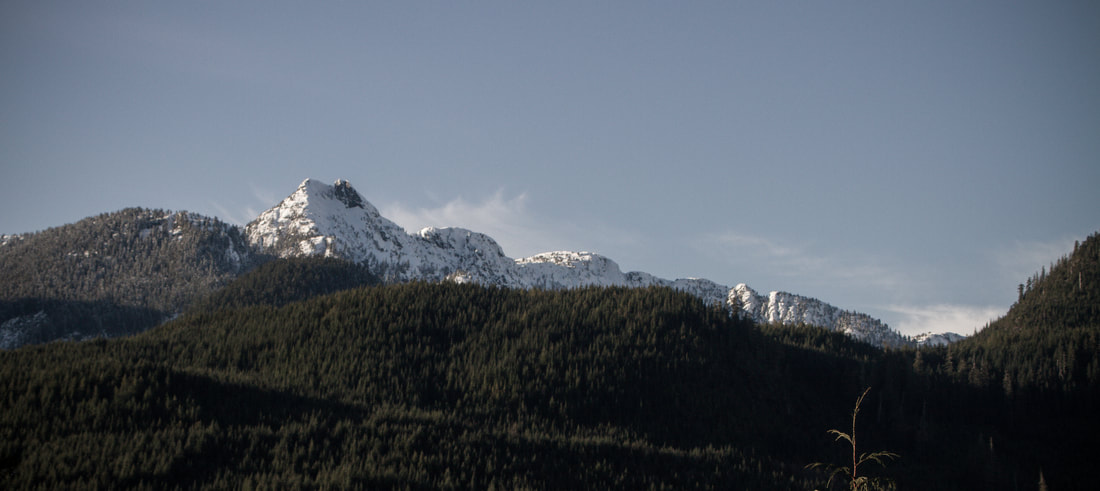 Upper, Upper, Upper Gold River valley views
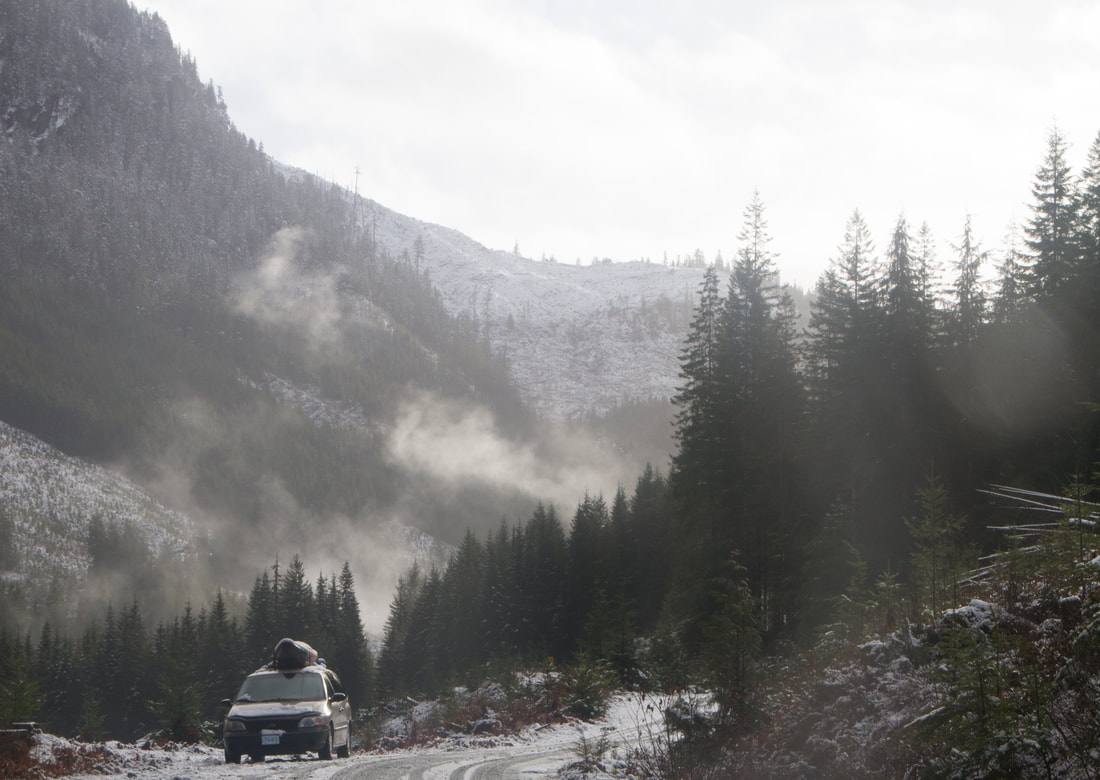
Well storm it did, first the rain then the snow. Luckily I had tarps galore to cover my wood and fire. Still it was not that pleasant to have to get out of the warmth of my sleeping bag to start a fire with a heck of a lot of snow on the ground. For the next few days I huddled to keep warm, and during the lulls of the storms I was able to get out and paddle a few beauty creeks in the area. I also managed to do some interesting descents of the far upper reaches of rivers, these being the Gold river from near the head water lake and the upper, upper, upper, upper Heber (above the flood run) . These required some interesting portages around some sieve filled rapids, and the later having a long walk through the snow. 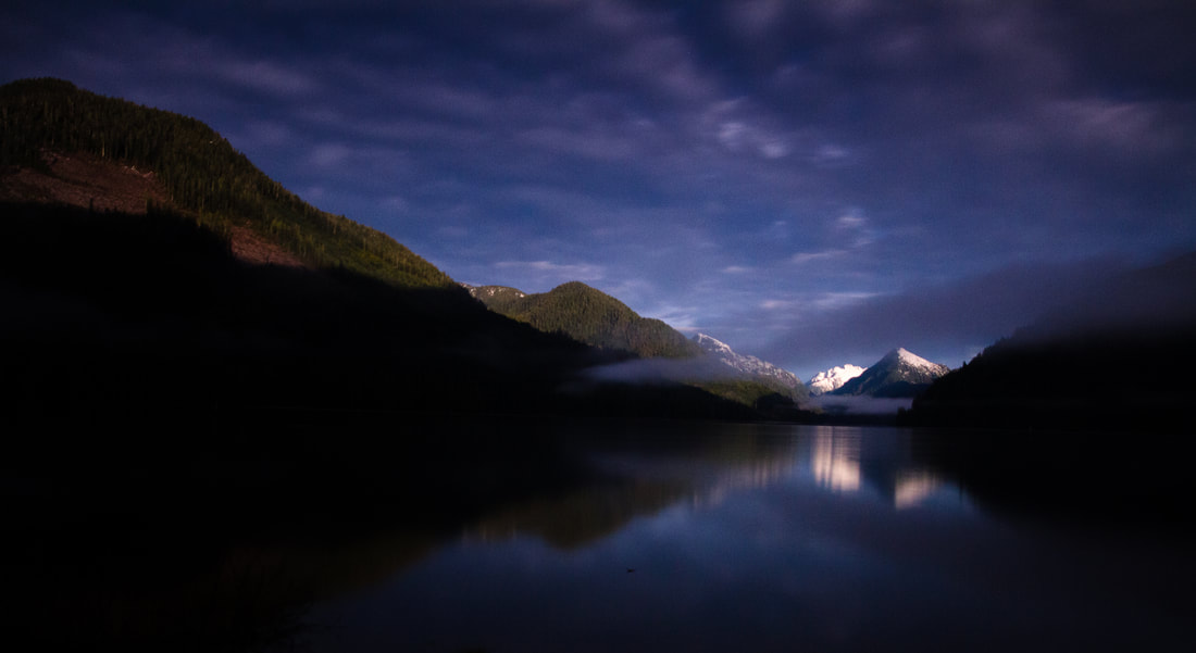 A still night on Machalat lake, Gold River
Heralding the endI did not spend as much time boating on the Gordon as I would have liked, the water was dropping out and fast! All the huge storms from earlier had given way to dry cold weather. I did however see some HUGE trees. Unfortunately Weebly will not let me upload photos larger than 10mb and BIG trees need BIG photos, so I can't upload them. However bellow is a photo of the protection camp I stayed at. 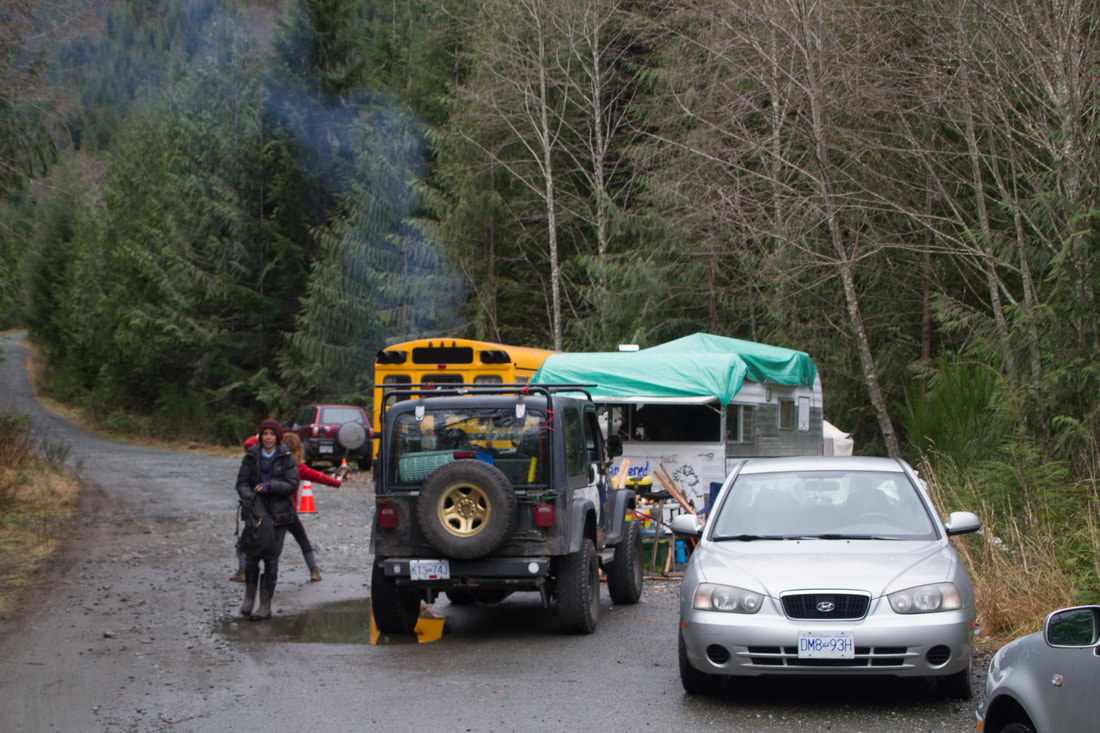
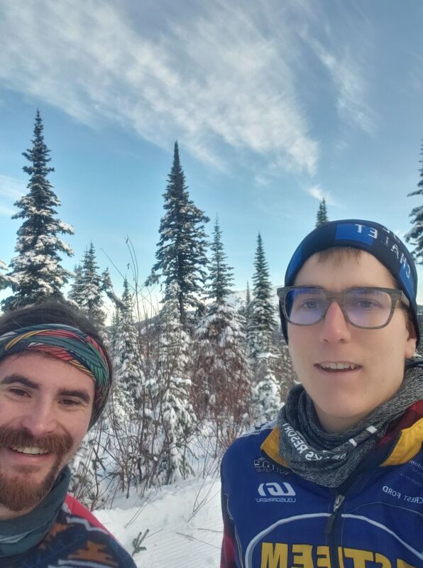
I had not seen my uncle for over 10 years, possibly 15. So it was amazing to catch up for a couple of days as well as meet his friend. After two days I headed back to Kamloops to see my friend Tony. Unfortunately he dislocated his shoulder downhill skiing a couple weeks back, so he could not get out and about. I however, went for a two long skis than on the third day Tony and I teamed up for a long tramp through the woods on snowshoes. We did not bring food or water, so 15km later we where rather parched. Nothing a cold beer and some nacho poutine couldn't fix. I have now left Tony's, although it turns out I left a sweater and some socks...wups. He has offered to meet in Kamloops for a brew and to return my stuff. in other news I need to figure out insurance crap for my car, but that is tomorrows problem.
0 Comments
Getting thereAlthough some people opted to leave their countries during the debacle of 2020, I decided to stay and enjoy the great country that is Canada. Purchasing my first car was a challenging task, but in the end a van was acquired and the drive across the country commenced. For those that have not driven across the country, Ontario is really BIG! for those that have driven across the country, let me remind you that Ontario is BIG! Big, but beautiful. I followed Lake Superior, as I have been on the northern route several times. I had no idea that there where mountains in Northern Ontario (remember mountains are relative, the highest of these is only 600m) the huge cliffs, fiords and mountains kept me entertained as I drove along the coast. Leaving Lake Superior, the land scape begins to change. Flat black spruce country dominates the drive as I entered Manitoba, three days after leaving Ottawa. I opt to drive through Winnipeg that night, camping in a farmers field on the other side. The next day, although monotonous it is very interesting. It has been a decade since I saw the prairies, and the flat treeless scape was more interesting the monotony of the black spruce, only because it was different. The Game of Thrones audio book entertains me through this section. I am now gaging my process based on the completion of this book. so far I have driven most of the way across the country, and yet to have finished the book. I am not sure what is bigger, the book or Canada Turns out Canada is bigger. I camped in Alberta, and completed the first book. On to the second book, and meeting up with my friend Ben
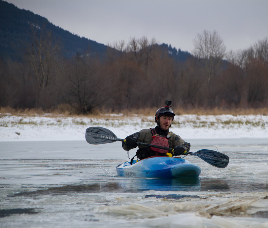
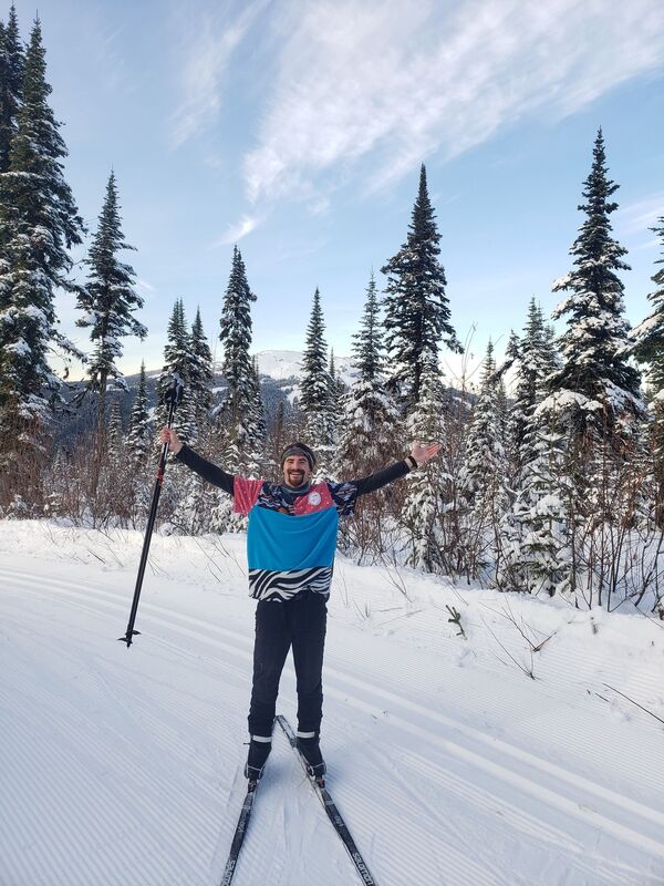
I spent a well need two days resting and relaxing at his house. On the second day we headed out to paddle a frozen Columbia River. It was frozen, but fun frozen. We finished of the day with a photo shoot and dinner at a local restaurant.  Way too chill. Photo by Ben Baber I left not so early so as to give time for the road to melt. It had rained that night and I was worried that the passes would be dangerous. My aim was Kamloops and my friend Tony's house. I have not seen Tony since our college days, he went west and and I left to travel the world. I spent four lovely days skiing, I have not skied in at least four years. It was so much fun!!
I spent some of my time enjoying the indoor comforts at Tony's house: WIFI, a bed, those things. I also made sure to camp in the area, in order to fully appreciate the surrounding land. I camped next to a small stream with a beautiful waterfall, and chalk full of salmon. I have only ever seen two types of salmon, the type in a can, and the frozen type. It was incredible to see so many live creatures, truly a thing of beauty. leaving Tony's I beelined to the coast, camping beside the ferry terminal. The ferry was uneventful and I spent most of the time reading and listening to the second book in the series A Song of Ice and Fire. From there I beelined up the coast to the small mountain town of Gold River A classic vista I spent my government mandated quarantine on the logging roads outside of Gold River. In the morning I would paddle the upper Gold River and than walk my kayak 6.5 km back to my car. After lunch I spent my afternoons walking the woods looking for mushrooms and big trees, and there where ample amounts of both. Upon finishing my quarantine I started the drive back to Campbell River, and the coast. Unfortunately my check engine light started flashing. I have a known torque converter problem, I hope that I can just fix that and not have to replace the whole transmission.
General Information
Number of participants: 2 Number of days: 15 Water Level: Low at the top medium high at the bottom. Trip Dates: Two weeks at the end of September into the start of october Total KM: 410 Total Elevation drop: 1750ft Maps used: 1:50000 (23 A/12 west, 23 B/9, 23 B/10, 23 B/7, 23 B/2, 22 O/15 22 O/16, 22 O/8, 22 O/9, 22 O/1, 22 J/16, 22 J/9 22 J/8) Gauge: http://www.cehq.gouv.qc.ca/Suivihydro/graphique.asp?NoStation=072301 General weather: Average for end of September and early October. We had two nights well below zero, and some flurries. consistent rain on the river, which is normal for this river (the name Moisie is French for moldy). We were very lucky on the lakes and only got wind bound for half a day. Pace of trip: Pushed at the start through the lakes, relaxed on the river. Campsites: Mostly bush crash sites throughout the trip, we could always find a cozy mossy den. Lots of burn on the river so it made camping a little easier. We counted only 5 actual established sites on the river, most of which were in a poor state. Route overview: There three main approaches to the Moisie river. They are the Pekans river, the traditional lake approach and the Ashuanipi crossover approach. I have included a breif description of each. 1) Pekans river: The Pekans is the largest river right tributary of the moisie (and possible its largest). You access it from QC route 389 from Baie Comeau to Labrador City. It starts around 2000ft, joining the moisie around 1400ft. It is roughly 100km long and contains a variety of class 2-5 whitewater. The confluence falls are stunning, but a 1500m portage. Logistically this makes more sense with more people, as one could drive to the put in, then put the car on a cargo train to Sept Iles (roughly 450-500$). Below three people it becomes more expensive. Annotated maps for the Pekans approach: http://www.cartespleinair.org/Canot/07/PekansMoisieGoutier2019.pdf http://www.cartespleinair.org/Canot/07/PekansMoisieKovac.pdf 2) Traditional lake approach: Take the train from Sept Iles to the Lab city station (the train no longer runs to lab city, you are put off on the side of the highway) from there, organise a taxi (ideally pre arranged) to pick up you and your equipment and drop it off at Lac deux Miles. These lakes are less big than Ashuanipi, but are still very large. This option takes roughly the same time as the Ashuanipi crossover Annotated map for the traditional lake approach: http://www.cartespleinair.org/Canot/07/DeMilleMoisieGoutier2019.pdf 3) Lac Ashuanipi crossover approach: This is the most physical option. We chose this option because we could not enter Labrador during Covid (I mean we did, just not any cities). This route is great for the following people; those looking for adventure, those that have done the Pekans, and parties less than three. although it is the hardest physically it is the easiest logistically. take the train from Sept iles to station Orway, and off you go. Annotated map for the Ashuanipi crossover approach: http://www.cartespleinair.org/Canot/07/AshuanipiMoisieGoutier2019.pdf Lake Overview: Ashuanipi is a huge lake! It can get very big and windy very fast. We were very lucky we had dead calm and were able to take a big chunk out of it the first day. We planned a half day of being windbound. We could have been wind bound a full day, and could have made the time up on the River. That being said being windbound and slowed more than a couple of days it would start to get dicey. Crossover Overview: the portage is easy to find and follow, at the time of this writing it was very well flagged (thank you, thank you). It is wet and physically challenging. The creak is a drag (literally) Whitewater overview: This is probably one of the best class 3/4 multiday rivers in the world. Overall you want low at the top, high at the bottom. There are a variety of different styles of white water from creaky side channels to supper fun big water rapids. We had low water up at the top, and could have had a wee bit more (half a foot to a foot), and medium high at the bottom. The last days rapids were an incredible 650cms of huge waves, some pushing 12ft tall. It reminded us of high water Lunch Stop waves on the Ottawa River, for 6km. The Moisie floods easily, but can take water. During our last week we saw the river rise about 2ft. The upper section has a creaky vibe and has 3 class 5 rapids, the rest are no harder than 4+, but mostly class 2/3. The River changes to big water after the Pekan river confluence. From here down there are 4 class 5 rapids, all are easily portaged or creaked around. A note on Rapid Katchapahun. It needs very, very low water to be runnable, any amount of rain will likely boost it to an unrunable flow. The portage is a workout, but you have to earn your turns. Schedule: We planned on going for 16 days (plus an extra day of food) we cut it short because it was raining during the good hiking days. we would highly recommend bringing the same amount of food so you can hike. We hiked a lot in 2011 and it was incredible. Sept Iles: Great Town to Start an expedition in. It has everything that you would need, Walmart, Tims Ext. Hot Tip, Gino's has really good pizza, but Marcos in Baie Comeau is better. To sleep; there is a wide variety of hotels and motels, a thriving Tinder scene, the Walmart parking lot, and a quiet little park near the train station. The Train: Take it!!! it is so beautiful out there, never once was our group board. The train ride is absolutely stunning. The flat water is not really that bad (although it can get quite windy), and It also gives you time to figure out your systems for your group; morning rituals, packing your boat and how your boat feels fully loaded. Lastly: YOU HAVE TO EARN YOUR TURNS!!! nuff said. You take the train from Sept Iles to station Orway (7hrs) and is a fixed price of 50$, but your kayak can cost really what ever the person at the desk decides to charge you. Do not call it a kayak, do not call it a canoe. Say it's a wave ski and it's over 4ft long. Hopefully this will cost less than a canoe (140$). We however payed 150 for the kayak, and 10$ extra weight. Trip Report Day 0 HoW: 540-720pm Distance: 5km Weather: clear, light headwinds (from West), Frigid Campsite: 997 267 23 A/12 west (island bush crash across from station) Day 1 HoW: 9-4 Distance: 25km Weather: Dead calm, cool Campsite: 850 250 23 B/9 (esker island, burn) Day 2 HoW: 10-1245 Distance: 7km Weather: Heinous headwinds (from west), cold Campsite: 805 267 (the point) Day 3 HoW: 9-530 Distance: 16km as the crow flys Weather: Annoying side wind (from west), cool and clear Campsite: 668 288 23 B/10 (shitty bush crash in from beach) Tech
Day 4 HoW: 9-3 Distance: 20.5km Weather: Hot, sunny, light wind headwind (from South West) Campsite: 618 104 23 B/7 Tech:
Day 5 HoW: 930-430 Distance: 20km Weather: Overcast, warm Campsite: 525 977 (beautiful hill, amazing!!) Tech:
Day 6 HoW: 9- 440 Distance: 22 km Weather: Mix of sun and clouds, light rain in the aft, cool Campsite: 516 763 23 B/2 Tech:
Day 7 HoW: 10-330 Distance: 29km Weather: Snow (flurries), hovering around zero till the pm when the sun came out Campsite: 682 506 22 O/15 Tech:
Day 8 HoW: 10-4 Distance: 23km Weather: Below zero when we woke up, everything was frozen. Warmed slightly in aft, rain in pm. Campsite: 826 282 22 O/19 Taoti river, actual campsite Tech:
Day 9 HoW: 10-2 Distance: 16km Weather: Rain all day, warmer than the day before, but still cold. Stoped early because of rain. Campsite: 838 107 22 O/9 Old site, amazing view, amazing hiking. Would recommend that you stay here, if only to enjoy the next day’s canyons more. Also there were not a lot of camping options after this for a while. Tech:
Day 10 HoW: 940-3 Distance: 32km Weather: Very warm and sunny Campsite: 897 810 22 O/8 Hot Tip: Keep the camera ready budget time (half day or full day) to hike Tech:
Day 11 HoW: 10:30-330 Distance: 20km Weather: Warm, crazy misty all morning, rain the night before Campsite: 875 600 Haut Moisie Camp Tech:
We slept by the river on the helipad. There is a note on a small cabin by a sandy takeout that says the outfitters are closed for the season but canoe trippers are welcome to use the “small log cabin”. The sign is from 2008. It looked like the sight was in use, but the occupants left the day before. Day 12 HoW: 945-215 Distance: 31km Weather: warm and rainy, strong winds in aft. (from south) Campsite: 827 350 22 J/16 small established site Tech:
Day 13 HoW: 940-330 Distance: 38km Weather: Mix of sun and cloud, cool, wind from south in aft, rain in the evening Campsite: 024060 22 J/9 small beach, great if you like beaches. There are gravel bars a couple km upstream. Tech:
Day 14 HoW: 1045-300 Distance: 23km floated most of the way after the nipissis Weather: mix of sun and cloud Campsite: 014 857 Gare Tellier 22 J/8 Tech:
Day 15 HoW: 10-130 Distance: 25km Weather: Very warm, no wind Campsite: the end Tech:
It's a long oneStep one: getting to the airport.
On the 7th of November I left from Arequipa to Lima on a short 17hr bus. It ended up being 18 or 19, but who's counting. The day before I went to the bus station to deal with my kayak, my plan was to leave it there over night and travel with it the next day. For a nominal fee they offered to send it that night and I could pick it up at the terminal. Great send it! I arrived in Lima at 11 or 12 at night, and low and behold the terminal is closed, with some sleuthing I find out that the terminal opens around 5 or 8 am. This is not very helpful as my plane leaves Lima at 830am Ergh... I walk around the area and find a hotel (a bit pricey) and sleep for 3hrs. Waking up at 4 in the morning I walk the 20-30min back to the terminal in hopes that it opens at 5am... It does Yay!!!! Now each company has an office, surrounded by a 10 foot high fence. There is one open (not my company) but, beside it is my bus companies office, with my kayak. Safe and sound, and locked behind a 10 foot fence. Ergh Turns out that my bus company's office opens at 8. Well that will not due, as I have a flight at 830. And so begins the pleading, and the begging. I show them my ticket, my luggage tag and my receipt. The are not having any of it. It would be robbery they said, a breach of contract, go away and come back at 8. At one point I am fed up with the bulshit, I hop the fence in order to steal back my kayak. This pisses them off and they lock me inside the office and threatening to call the police. I see this as a turn for the better. Please call the police. They will help me get my kayak back so I can go to the airport with my boat. After some convinceing by other parties I am let free. The begging and pleading continues. I show them photos of my kayak on my phone. But alas they are hearing nothing. Time for action! In a lul in the arguments, I walk back into the office and successfully steal back my kayak. I left the receipt along with the baggage tag. The transaction complete, although a slight lucrative I walk out the front gate and get the first taxi out. Step one complete... Step two: getting on the airplane. I arrived at the airport at 630 am right on time for check in. Upon arriving at the counter I was quickly notified that I had an outstanding balance, equalling to the price of the ticket. ??? Now as many of you who use credit cards know, the card works or it doesn't work. Simple. The friendly ticket agents, and management did not seam to understand this. Nor did they understand that my receipt, issued by the company should be enough to confirm that I have payed. Becoming more and more frustrated I showed them that the money had in fact exited my account, and was payed according to visa. We settled on 5.67usd handeling fee. Grand. The usual boat drama ensued and we settled on 30usd to transport my surfboard, waveski, whatever the hell that thing is to Santiago. Breath... The time is now 745 boarding begins in 15 minutes Run... Ahh but wait, my river knife is still in my life Jacket. I guess security can have that. Run... I make it to the plane as boarding begins, now to settle in to the three hour plane to Santiago. Payed 40usd in Santiago to get my boat to Puerto Mont. Easy. In Puerto Mont I took the terminal bus to the local bus station. Then dragged my boat and bags to the ferry terminal, approximately 700m. A beautiful portage beside the sea with glaciated mountains in the distance. Stunning... Purchasing a ticket was a breeze. I even got 30% off on my ticket as there was a promotion. My kayak unfortunately ended up being double the price of my ticket. A classic situation. The ferry leaves at 11pm and arrives at 9am. I settle in on a bench and enjoy a comfortable and we'll needed sleep. Arriving in chaitan the next day I am greeted by huge glaciers. Unfortunately the free transport bus will not accommodate my kayak. All good luckily a good ol' boy with a pick up can take me into town. Yay I don't have to walk a km into town. At 11am the bus to futaleufu arrives, unfortunately it is way to small to accommodate a kayak. Ergh. And so begins a km or more walk out of town so I can hopefully hitchhike my way there. I got picked up around 3ish by a lovely couple heading up for an afternoon fish. As we drove to the Rio Yelcho my jaw was on the floor, I wasn't sure where to look. Everywhere there where huge glaciers. Omg... I was treated to a late lunch of chicken and beef bbq. For dinner and breakfast, fresh trout from the Rio Yelcho. Luxury. The next morning I was quickly picked up by some truckers heading past the turn off to Futaleufu. Great people, but could not understand anything they said. Arriving in Santa Lucia I excitedly began the wait for the next ride Yeet yeet!!! It would not be for another day and a half. With a total of 2 days spent in Santa Lucia here are some facts about the town Population: a couple hundred at most Economy: tourism and car repair Two years ago a mud slide came and destroyed half the town and killed over 25 people. I was picked up by a young man who works for the state tourism board and had lovely conversations till we arrived in Futaleufu. The end, yay! 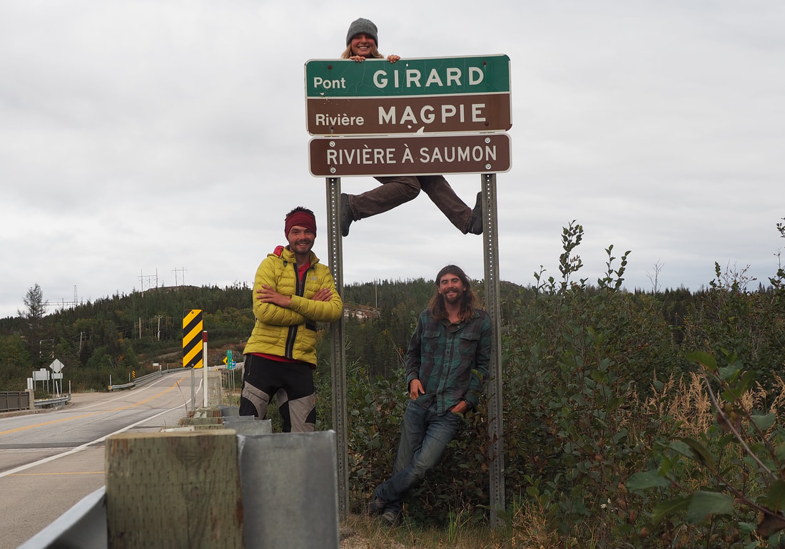 Photo courtesy of my friend Nick West Magpie river 2019
General Information Number of participants: 3 Number of days: 12 Water Level: Low Trip Dates: Two weeks in the middle of September Total KM: 260 Total Elevation drop: almost 2000ft Maps used: 1:250000 (22P, 22I) 1:50000 (22P/13, 22P/14, 22P/11, 22P/6 22P/3, 22P/2, 22I/15, 22I/8, 22I/9, 22I/10) Gauge: https://www.cehq.gouv.qc.ca/suivihydro/graphique.asp?NoStation=073503 General weather: average for September. We did not get snow at the put in, or in the first few days. But we have heard of people getting it. We did have ice in our bottles one morning. Pace of trip: relaxed. More time to smell the roses. My veiw, why rush through such a beautiful place, its a vacation enjoy it. Campsites: The flat water approach has many beaches and lots of cozy pockets in the woods, great camping. The West Magpie has lots of great camping as well. Lac Magpie is absolutely stunning and has plenty of beaches. We found that the Magpie was not as nice camping. Whitewater overview: The West Magpie is steep, continuous mountain river, a lot can go wrong out there. Scout often! The West Magpie has also been known to flash flood with sustained large amounts of rain. At our levels, Entrance Falls was the second biggest rapid on the river, the largest is the final portage gorge. The Magpie has a more traditional big water feel. Sept Iles: Great Town to Start an expedition in. It has everything that you would need, Walmart, Tims Ext. Hot Tip, Gino's has really good pizza! To sleep; there is a wide variety of hotels and motels, a thriving Tinder scene, the Walmart parking lot, and a quiet little park near the train station. The Train: Take it!!! it is so beautiful out there, never once was our group board. The train ride in is absolutely stunning. The “flat” water is not really that bad as the river moves at around 2km/hr and has occasional rapids. It also gives you time to figure out your systems for your group; morning rituals, packing your boat and how your boat feels fully loaded. Lastly: YOU HAVE TO EARN YOUR TURNS!!! nuff said. The Train ticket is fixed, but your kayak can cost really what ever the person at the desk decides to charge you. Do not call it a kayak, do not call it a canoe. Say its a wave ski and its over 4ft long. Hopefully this will cost less then a canoe (140$) Day 1 HoW: 230-630 Distance: 18km Weather: rain,sun,tailwinds, cold Campsite: 214 443 22 P/13 end of the last rapid, Lovely taiga, and soft caribou moss. Tech:
Day 2 HoW: 1030-4 Distance: 25km Weather: sunny, tailwinds Campsite: 346 285 22 P/11 tucked in the woods back from a beach, also on caribou moss Tech:
Shallow meandering, but moving river (around 2km/hr). All narrows have swifts. Day 3 HoW: 1030-4 Distance: 29km Weather: cloudy, usual northern weather Campsite: 417 154 22 P/11 Island campsite, this is an established site. Tech: n/a Synopsis: A wee bit flat, but the the river is still moving. Also look out for the really, really shallow areas. Day 4 HoW: 1020-4 Distance: 23km Weather: really cold, rainy, tailwind Campsite: 457 943 22 P/11 river left at a small beach in the pool after the Entrance Falls gorge. Tech:
Day 5 HoW: 1020-350 Distance: 19km Weather: sun, warm, a bit of cloud Campsite: 543 852 Large flat rock RL after the river calms down. It is marked by two crossed paddles high in a tree. There is also a broken canoe in the bushes up the hill. Elevation drop: 250ft Tech:
Wow The West Magpie Speaks! The views are stunning, if you take the time to look around from the white water. We have the utmost respect for the canoeists and rafters who have walked down this river. Day 6 HoW: 11-4 Distance: 28km Weather: warm, sunny, bit of cloud Campsite: 607 592 Tech:
Day 7 HoW: 9:30-7 Distance: 22km Weather: cloudy, cold, sun, rain, literally everything Campsite: 815 547 22 P/2 Elevation drop: 500ft Tech:
A lot can go wrong today, take your time and scout. Day 8 HoW: 1-4 Distance: 12km Weather: Tailwinds, sun and cloud got cold at the end Campsite: 850 433 22 I/15 Tech:
Day 9 HoW: 1030-445 Distance: 23km Weather: hot, calm Campsite: 866 208 I/10 Tech: N/A Day 10 HoW: 1010- 345 Distance: 28km Weather: cloudy, chilly, head wind Campsite: 994 205. Should have pushed a little further, there would have been something nicer Tech:
Day 11 HoW: 10-345 Distance: 26km Weather: cloudy, slight head wind, warm Campsite: Bellow the massive Magpie Gorge 986 812 RL. There is also a camp 100m into the portage. Tech:
Day 12 HoW: 10-12 Distance: 6km Weather: grey, rainy Campsite: N/A Tech:
A short and long out dated post on the Badi GadThe ins and outsThis is a secret river, and has had only a hand full of decesnts since its first in 1999. There is now a road, so you can get to it easily from Pokhara. You start right at the top! Two creeks join creating one that at our water level was just suitable for kayaking. By the end of the river there was a good 25cms. The people are incredibly friendly, all though the people in the village at the end of the river tried to take advantage of our situation.
Water Level: low! Put In 1)Bus from Pokhara to Baglung 3hrs. Very good good Momos in the Baglung bus park, in Baglung. 100 NPR for buff momo with soup, maybe the best buff momo I have had in Nepal. 2)Mini bus from Darbang to burtibang 7hrs. this left at 3pm. You could probably walk to the main highway and hitch your way to Burtibang. We camped in the construction sight beside the river. Take out 1) paddle down the rest of the Kali Gandaki 2) hire a jeep from the town at the bottom (we paid 10 or 11 thousand) as there is no bus. Day 1: 1) lovely continuous C4 (4+) boat scouting for a couple Kms. this eases into c2/3. 2) Short (30Min?) paddle down the landslide lake 3) 200m portage around lanslide rapid. Portage is RL along the road. 3) 2/3 with some spice to keen you awake. 4) before we camped there are some lovely read and run C4 rapids 5) camped RL at a small town (in there volleyball court). Very hospitable people, very good dahl bhat. Day 2 1) Long day! 30km or so of flat (1/2) Camped on a beach RL in the town above the G4+ section, had dahl bhat in the village. Day 3 1) Short Paddle till the start of the G4/4+ (5) This section was mostly read and run, with only a couple of scouts. This section only takes a couple hours to paddle. The white water is classic Nepal, all smiles. dal bhat power 24hr Phewa Tal, the smallest mountain is a meter short of 7000. Pokhara is ringed by giants. As usual I left my family in Ottawa to go back to my Nepali family at the start of October... I preface with this because as usual I write a blog post 6 months after what ever I intend to talk about. So here is my year in review.
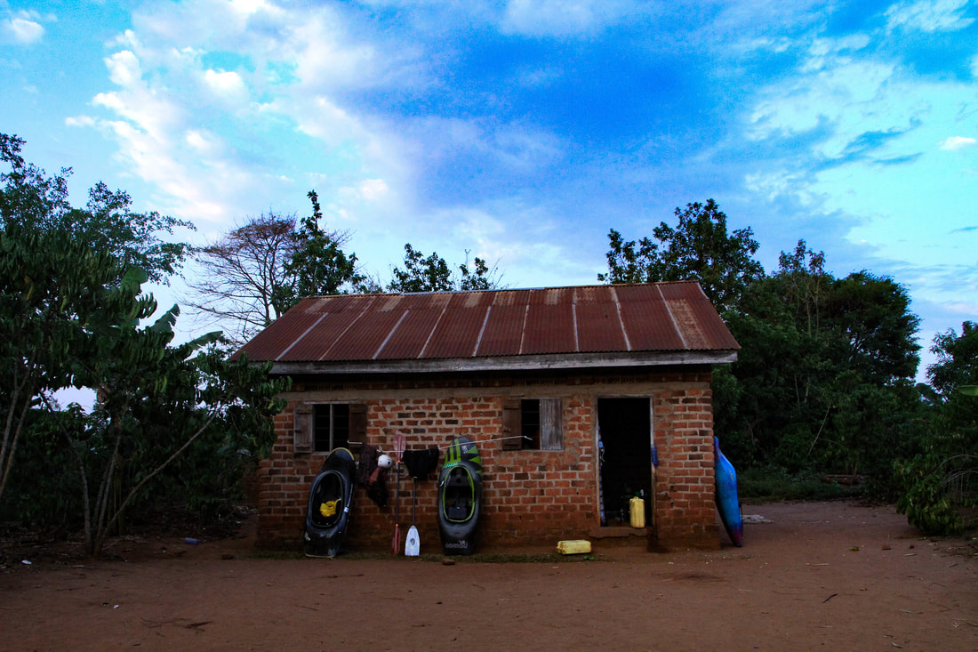
My original plan was to stay in Nepal for as long as possible, then go some where in Asia. The issue it turns out was a lack of water in Asia. Countless companies in India, Vietnam and Indonesia, said that there just was not any aqua. :( where else to? I headed back to the Nile. Uganda Nile river sunsets in my opinion are consistently the best in the world. 400 cnd lighter (boat transport fee) I was on a flight bound for Qatar, then Entebbe Uganda. After a surprisingly short taxi to Jinja (thank you Pineapple Express) I arrived at Moma Flows, and with a belly full of Irish potato and matoke I went to bed. This is where you shit, This is where you eat, this is where you sleep, and that's where you kayak.... |
| When Tom Dunphy said he was moving to the village obviously I was in. Cheap accommodation, close proximity to the river, sounds like Fraser As the days rolled in to weeks, and weeks to months Village life became my life. I am no stranger to the hardships of life on trip. Pooping in a hole in the ground, and cooking on a fire or stove. What I found hard was getting the required calories that I needed. By the end of my stay I was ready to leave, I was emotionally and physically done. | 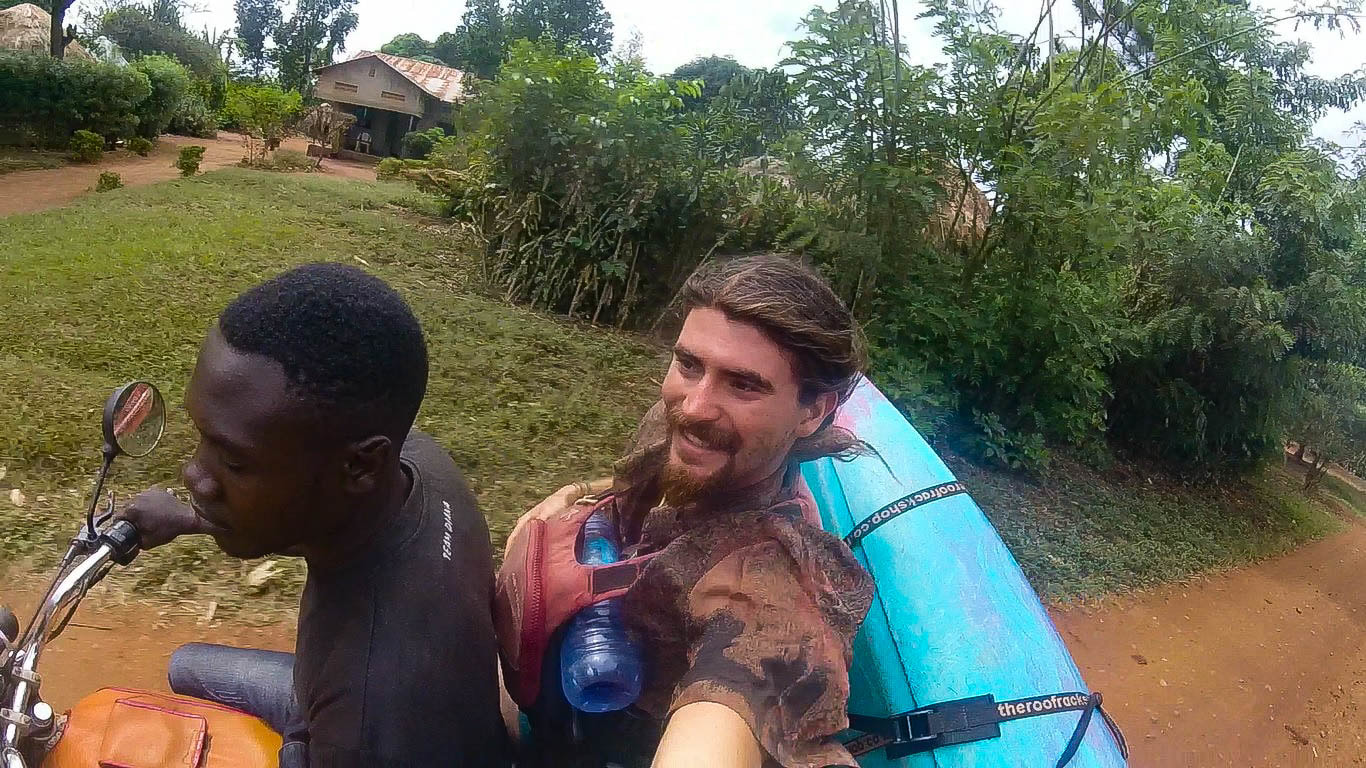 The Boda boda, Uganda's iconic river shuttle. |
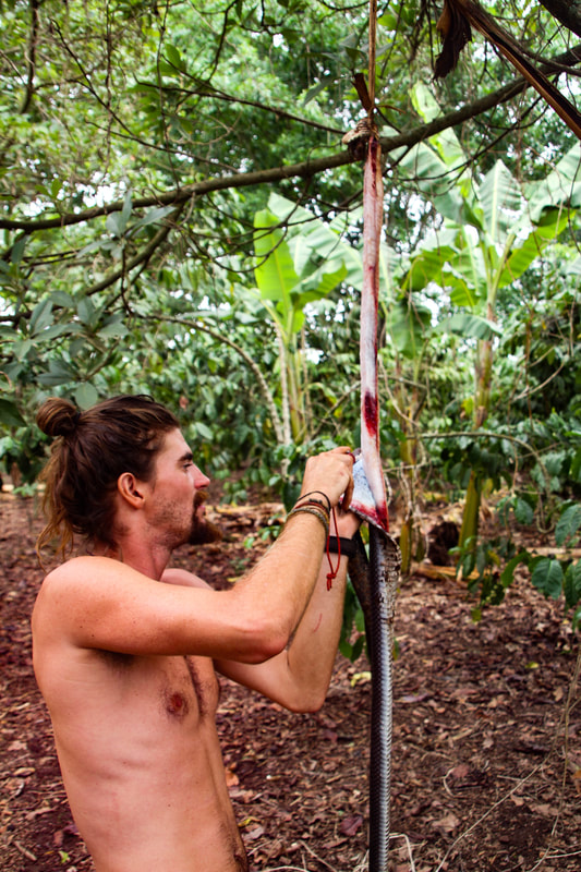 6ish feet long this cobra was found next door. I decided to make a wallet. | Personal growthLooking back on my last few months living in that village, I have gained so much as an individual. I have never in my wildest dreams thought I would have the opportunity to skin an animal. I mean I have always wanted to get into hunting, I just thought my first introduction would be on a deer not a 6ish foot long cobra. The aforementioned animal was found next door and was dispatched. Very sad! An animal like this should not be around humans, but with so much deforestation they have no home. The kids then used it for two days as a skipping rope, I tried it a couple of times but found the idea very macabre. I then took away their toy, and skinned it. I obviously have never done that before, but have a reasonably good head on there my shoulders and made quick, although some times sloppy work. From then I needed Google in order to tan the skin. |
| Making the wallet was a cool experience and made a great souvenir, but it was not the most important thing a brought back. What really blew me away is difficult to put into words. 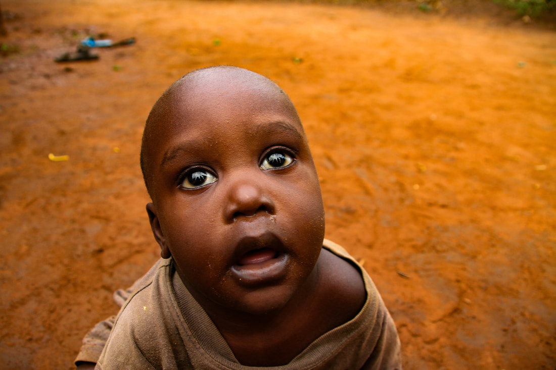 Ali, a constant source of entertainment | 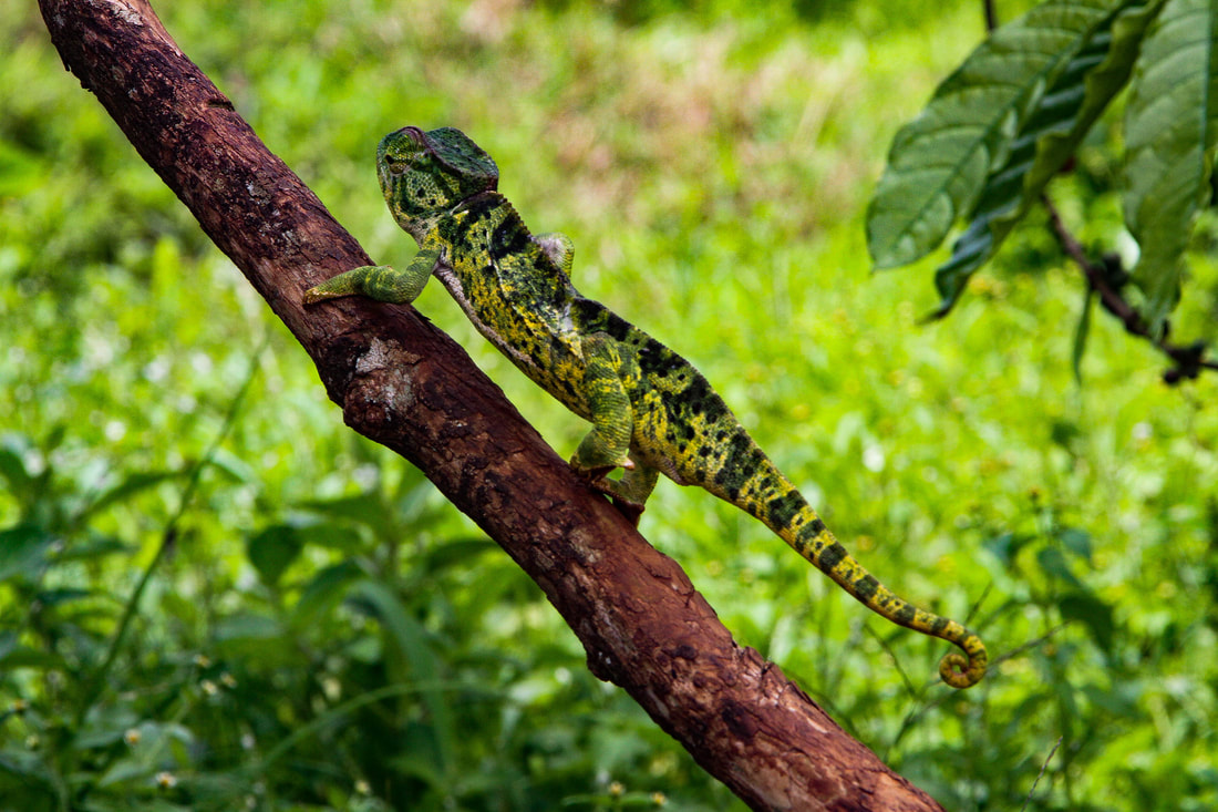 A gecko, mid color change |
Some of the children, left to right: Joan, Vegam, Regan, Joy, Teddy, Ab, and Ali
For three months I lived in area where poverty, death, and malnutrition are very prevalent. When we first arrived one of the children's parents died (unsure the cause of death), in the my time there another's father would drown in the river. I lost about 25lbs in those three months, but that is nothing to the countless bloated bellies, there were days when if we had not given out our left overs, children would not have eaten that day.
That's powerful!
That's powerful!
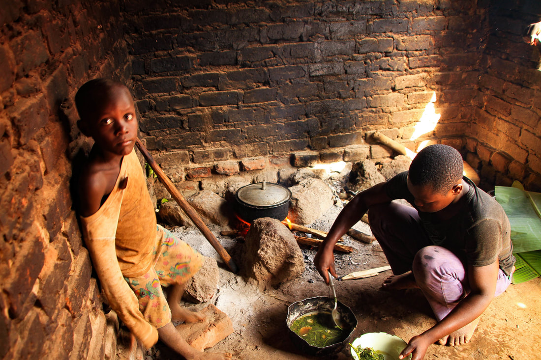 The local kitchen. Hasan (one of the regular cooks) makes a sauce from a local plant to be served on posho (a corn based food) while Ab watches. | So how did we give back. By creating jobs. Dishes where washed by the kids for 500ugx (17 cents Canadian), these where done once or twice a day. the house was washed for 1000 ugx and done once or twice a week. I say these numbers first because a kilo of Posho 1500ugx. you only need one or two kilos to feed a family. Sometimes the kids would ask to us to save the money they where earning and buy them a ball. The joy in the kids eyes when the receved what they had worked so hard to get is intoxicating. The aftermath, when 30 kids are playing outside can be irritating. |
| Some times the money would go towards food sometimes it would go towards sweats. I don't care. When I was a kid my parents would give me a bit of pocket money so I could learn to save, or buy candy. These kids have to grow up so fast its sweet when they can just be kids once and a wile. 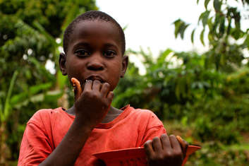 Joy enjoys some sweet potato | 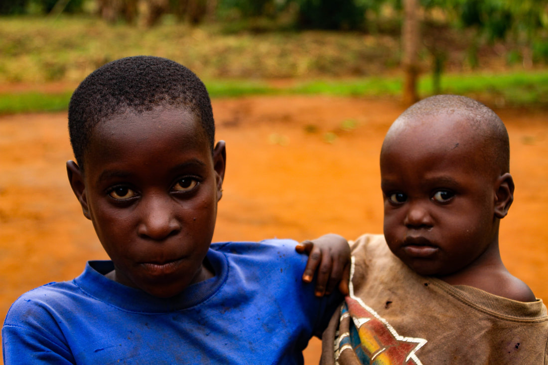 Joan and Ali. Joan's parents died when we first arrived. she takes care of the younger kids, cooks food and runs a small shop. She also goes to school. |
Big Hole flushes
Hypoxia
This is by no means a guide on how to run this rapid, however there is a lot going on and I would like to explain it. The first things is convincing your self 100% that it is a safe and good idea to do. To do that you need to understand what is going on with the water. Finally, safety is imperative! You need a good safety team at the bottom and on shore.
Holes
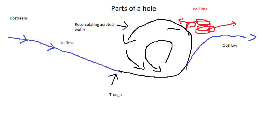
 Hypoxia: as drawn on Paint | A hole is formed when the river bottom drops in elevation, because there is an empty space water needs to fill this space, this is caused because of gravity. 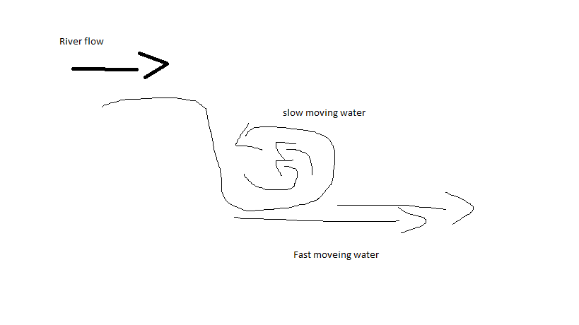 |
types of holes
There are three different types of holes, they are: smiling holes, frowning holes and ledge holes
| Smiling holes are generally considered 'good' holes. This is because exit points face downstream, making it easier to release from the hole. They are called smiling holes because if you put two 'eyes' down stream of the hole it looks like a smile :) from upstream. | 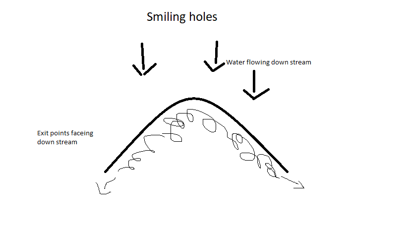 |
| Frowning holes are generally considered 'bad' holes. this is because the exit points face upstream, making it harder to release from the hole. They are called frowning holes because if you put two 'eyes' down stream of the hole it looks like a frowning face :( from upstream. | 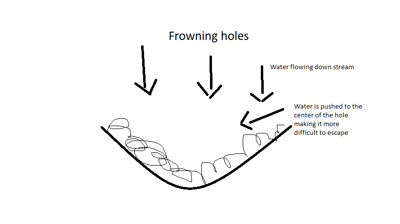 |
| Ledge holes look like a ledge and depending on the circumstances can be very bad. The worst, the low head dam (called a drowning machine) is bad because there are no natural exits except the bottom. It is often very hard to exit because one must crawl along the river bed to get out (self rescue), or someone must rescue you via shore, water or both. These holes (often called weirs) do appear naturally, and are blocked of on ether side by rock or water. Ledge holes can also be angle meaning they have one release point angled down stream. | 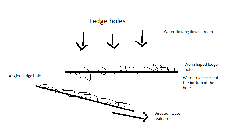 |
Hydrodynamics, what I know of it anyway
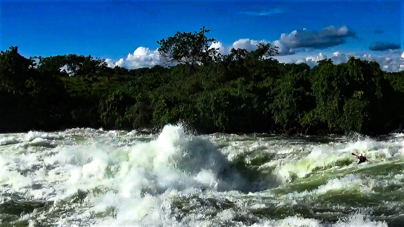
The Bad Place, Source: Google images.
So I don't know too much about this, and I am sure my friend Ben will cringe if he reads this. However, here is how fluid dynamics relates to white water, and in turn how it relates to holes.
| The flow of water in a river is a sandwich of different layers; surface flow, laminar flow, helicoidal flow, bottom flow. Surface Flow is the top layer. It is the slow moving aerated water at the top. When you are paddling in a rapid, this is the area you will spend most of your time. It is slow moving because of the friction against the air and the next flow. Laminar flow or linear (straight) flow is the second layer. It is the fast moving water that if you have ever directly jumped into white water, or capsized from your boat. You have most likely felt your self being swept-ed away. this is that layer. It is fast because of minimal friction. Helicoidal flow is responsible for everything that we see on the surface; waves, boils ext. as the water moves down hill it is pushed up by hitting objects off of the bottom. The larger the features we see on the surface the deeper the river. The Helicoidal flow hits the laminar flow bellow it and is pressed up, it in turn pushes the surface flow up creating what we see on the surface. Laminar flow or linear (straight) flow is the tertiary flow. It is a fast flowing layer at the bottom of the river it is relatively unhindered as it moves in a straight line up and over any undulations and rocks on the river bottom. As it follows over these undulations it pushes the helocoidal flow upward. Bottom flow like the surface flow encounters friction between the bottom of the river and the laminar flow above. This friction makes it slow moving. | 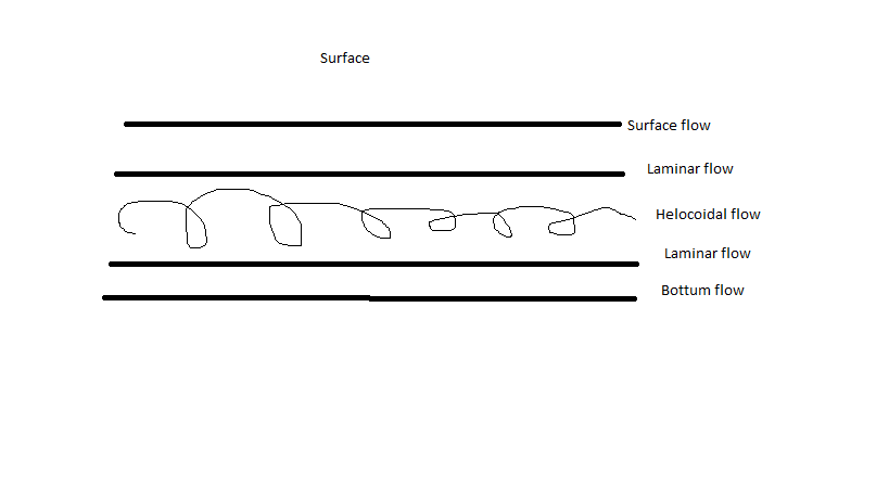 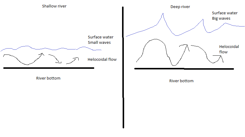 |
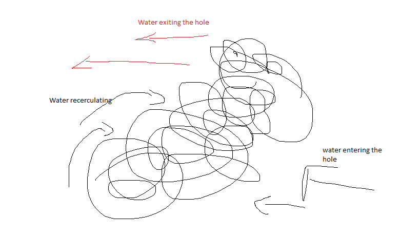
The big hole flush
Now that we know a bit about holes and types of water lets put it all together.
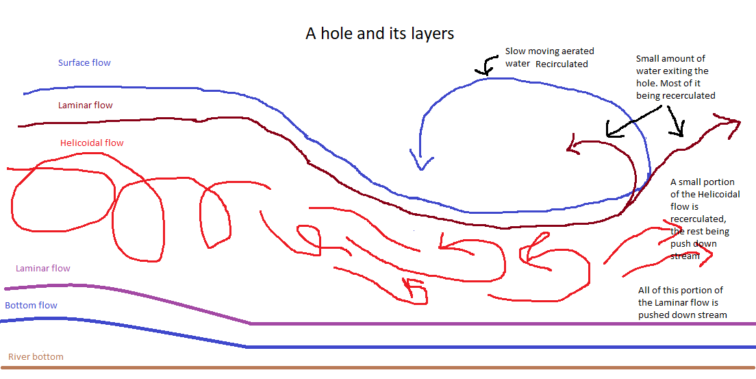
The Idea when flushing through a big hole is to catch the helicoidal flow and allow it to push us as deep as possible so it (the helicoidal flow) pushes us out, or pushes us into the deep laminar flow at the bottom of the river. As you can imagine it would be less then ideal to be in stuck in the slow moving aerated water at the top of the hole. The top Laminar flow dose push out, however its not ideal.
Determining whether passing through the hole is a viable option is usually pretty evident when scouting the hole. Can I see water exiting the hole? How much is exiting? If the answer to these questions is positive then one may opt to go for the flush. If not, one may decide that the best line is walking around.
I was TRULY blown away !
 Boats ready to go
 Wow! I have always been told that Africa is a dangerous place, The media dose not help with this. It is true that many atrocities have occurred in the continent of Africa, no less Uganda. There where so many people that warned me not to go
Wow! the people were so nice, so friendly, and so welcoming.
Anyway enough ranting and raving. At the end of June 2017 I Traveled to Uganda to go and say hello and goodbye to the Nile. The adventure started right off the bat with my luggage staying in Canada while my self arriving in Entebbe (Uganda). I waited a day and a half for my boat and paddle then headed to Jinja for some white water boat riding. For the next 26 days it was almost uninterrupted kayaking, paddling deep big water rapids.
Namaste!
Well soon it will be time to begin the 36 odd hours back to Ottawa, and I thought I would take the time to chat about the last month in Nepal. Friendship would be the best way to describe my third time here. My goal in coming here was not to run the stoutest rivers, my goal was to foster a develop the friends that I had made the last two seasons, that and run really fun rivers every day. Nailed it! Nepal is fast becoming a second home, its mountains, rivers, but especially the people are what have brought me back every year, and will bring me once again in the fall. Let me take a moment to describe it to you.
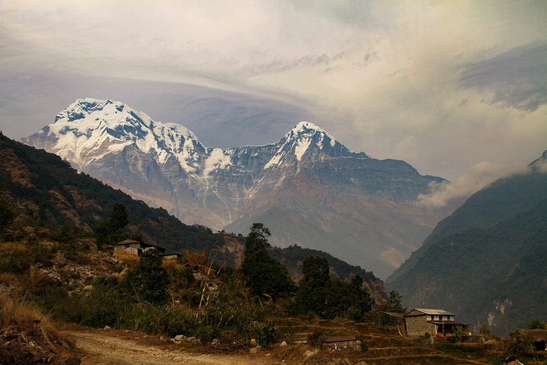
The mountains
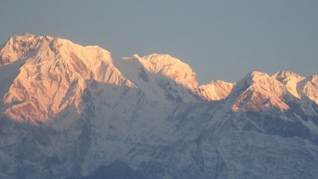
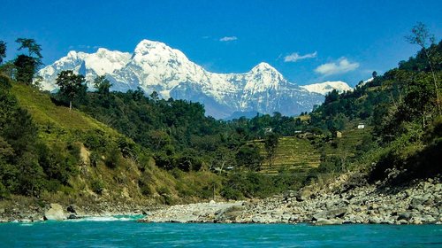
Some of the Annapurnas. On the left is Annapurna South. In the center and slightly hidden is Annapurna 1 at 8091m
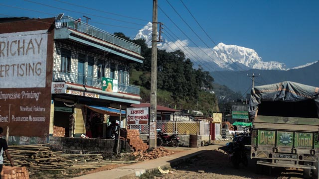
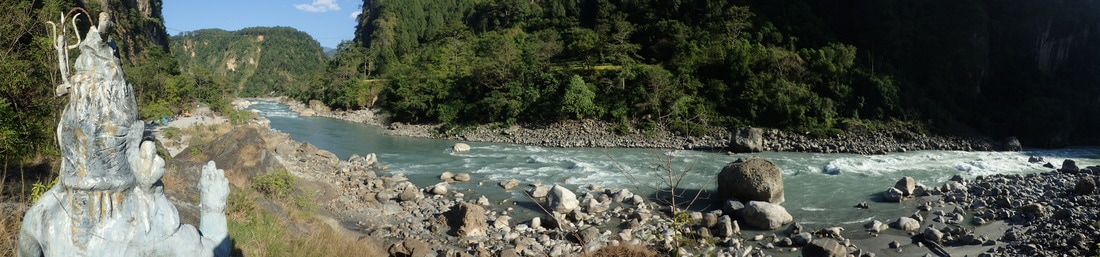
I am based out of Pokhara, lakeside to be specific to one side is Fewa Lake one of the most beautiful polluted lakes (cesspool?) I have been to. It is ringed on one side by the foot hills of the Himilaya, hills pushing 1300 meters. On the other side is the hustle and bustle of Lakeside, the tourist area of Pokhara. I spent many a late afternoon and early evenings sitting and enjoying the hazy sunset as it sets over the lake.
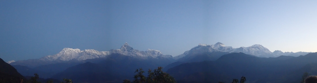
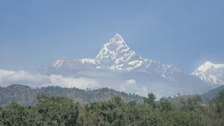 Machhapuchhre, the fish tail mountain
 Just out of site and often missed by the tourists on lakeside lies some of the highest mountains in the Himalaya and there for the world, the Annapurna Range. From just off of Lakeside on a clear day, or early in the morning theses monsters begin to show them self's. The most prominent is Machhapuchhre, just three meters short of seven thousand it dominates the skyline of Pokhara. This is a very holy mountain, the Nepali government have closed it to climbing as all that have attempted it have died. To the right lies Annapurna 3 just over seven thousand meters. To the left, one of the highest mountains in the world lies hidden, at just over eight thousand meters (8091 to be specific) Annapurna 1 is over shadowed by Machhapuchhre, but is still a reminder just how tall the mountains can get. If you take a cab, or hike up to Sarangnkot (one of the taller hills in the area) for sunrise, you can catch, not only the magic of the Himalaya but the Dhaulagiri Massif far to to the left, Manaslu far to the right,and the start of the Everest range far, far to the right.
Morning mountain view from Saragnkot.
The Rivers
Kali Gandaki
 Driving out of Pokhara  Upper Seti 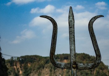 Shiva's trident | As you drive up and a way from Pokhara the mountains dominate the skyline, soon you leave Pokhara and are driving beside the Seti River (white river), known to the paddlers as the Upper Seti at this point. On a clear day you can see the full range with nothing but the occasional village to block your view-stunning. The Upper Seti is a home river, meaning that many people have cut there teath becoming good paddlers on this river. It is a classic Himalayan river, a continuous boulder garden. In the fall after monsoon dodge the BIG pour overs, in the spring when the water is low dodge the rocks, at ether time there are some very fun and creative lines to be had. If you keep driving up and away from Pokhara and over the next ridge, and you keep driving for a couple of hours you reach the Kali Gandaki River, one of my favourites in the world. for 2-3 days pool drop rapids, white sand beaches and mountain views around every corner. After the monsoon this river is very big, but once it settles a bit it is a fantastic run for all. Theses are just two of the many rivers in Nepal |
Shiva
The People
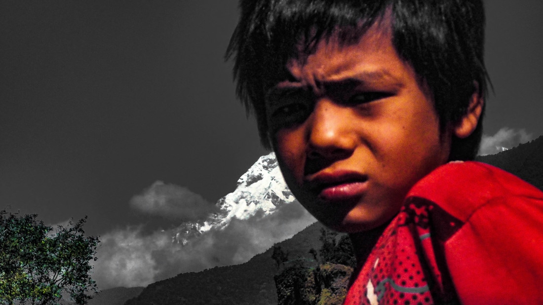 Child at the Upper Seti put in  Child at the Kali Gandaki put in | There are bad people everywhere, but I firmly believe that if you lost a young child they would turn up at the police station a few hours latter, fed and with snacks. The people of Nepal are genuinely nice! There is not much to say, they bring you in, welcome you to there homes and ask for nothing in return. Dhanyabad miro sati, Thank you my friends. I am excited to see you soon. 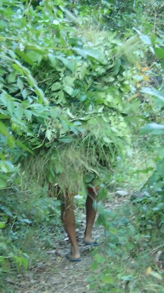 Is it a person or a bush? Or a someone carrying a bush... |
I was woken up at the crack of 8:30 this morning to my friend Ollie tickling my armpit. I have gotten way to used to sleeping in. The hour drive to the put in was silent and rainy. A quick coffee and pie was had the last 20 minutes where much more chatty. After a quick fix of a back band we were underway, paddling a low water Wairoa. To sum up today; I loved the river, did not like the day. For what ever reason my shoulders where in alot of pain today. My afternoon plans include lots of yoga!
Author
Hi there!
I'm Fraser, an International Outdoor Professional specializing in water, both liquid and frozen. Take a look at what I have been up to.
 RSS Feed
Archives
February 2021
December 2020
November 2019
September 2019
January 2019
April 2018
September 2017
May 2017
March 2017
February 2017
December 2016
May 2016
January 2016
January 2015
November 2014
October 2014
